mapping rome : basic roman topography 
Pincian Hill
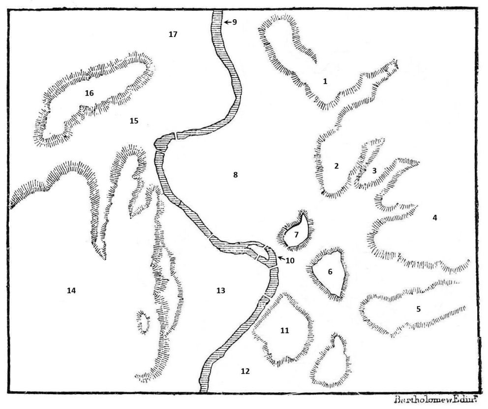
1. Pincian Hill (Mons Pincius)

NAME

  • The Pincian was known in antiquity as the Collis Hortulorum ("Hill of Garden-grounds") because of the many private gardens (horti) here.

  • The modern name derives from the Pincii family, who owned the hill in the 4th century CE.

ANTIQUITY

  • In ancient Rome the hill was occupied by the private residences of aristocrats and emperors.

MODERNITY

  • Today the Pincian Hill overlooks the Piazza del Popolo to the west, and is the site of the Villa Borghese, Rome's most famous public park, and the Galleria, celebrated for its sculptures by Bernini.

CANONICAL?

  • The Pincian was NOT one of the canonical seven hills.
Quirinal Hill
2. Quirinal Hill (Collis Quirinalis)

NAME

  • The name Quirinal perhaps commemorates a temple to Quirinus, the deified incarnation of Romulus.

  • An alternate tradition derives the name from Cures, the town from where the Sabines, under Titus Tatius, became the hill's first settlers.

ANTIQUITY

  • The highest of the hills in central Rome, the Quirinal was full of gardens and summer villas in the late Republic and early Empire.

MODERNITY

  • A papal summer residence, the Palazzo del Quirinale, was constructed in the 16th century and now serves as the official residence of the President of Italy.

  • The Gardens of the Palazzo are opened on June 2, the Festa della Repubblica.

CANONICAL?

  • The Quirinal WAS one of the seven canonical hills.

Viminal Hill
3. Viminal Hill (Collis Viminalis)

NAME

  • The name Viminal has two derivations: (1) a shrine to Jupiter Viminius ("Who fosters the growth of twigs"); or (2) groves of willow trees (vimineta) that reputedly grew there.

ANTIQUITY

  • The hill was a residential district from the 2nd century BCE through late antiquity, with few sanctuaries or public monuments, at least during the Republic.

  • The emperor Diocletian built his massive bath complex here in the 4th century CE.

MODERNITY

  • Diocletian's baths (thermae) have given their name to Rome's central Termini Station.

  • At least three city blocks' worth of ancient shops and apartments were leveled during the construction of the station.

CANONICAL?

  • The Viminal WAS one of the canonical seven hills.

Esquiline Hill
4. Esquiline Hill (Mons Esquilinus)

NAME

  • The Esquiline was believed to take its name from excultus ("cultivated"), a reference to the groves planted by king Servius Tullius.

ANTIQUITY

  • The hill was originally a collection of three different summits, the Cispian, the Oppian, and the Fagutal.

  • The Esquiline was infamous for its Vicus Sceleratus ("Street of Evil"), where Tullia, daughter of Servius Tullius, drove her chariot over her father's butchered remains.

  • The hill became a fashionable place to live during the late Republic and early Empire. Pompey, and Marc Antony after him, had a house here.

  • Maecenas, the wealthy cultural minister of Augustus, had a villa, which Nero incorporated into his Golden House.

MODERNITY

  • Near the Vicus Sceleratus stands the church of San Pietro in Vincoli, famous for preserving the chains that bound St. Peter, as well as for displaying Michelangelo's Moses.

CANONICAL?

  • The Esquiline WAS one of the seven canonical hills.

Caelian Hill
5. Caelian Hill (Mons Caelius)

NAME

  • The hill's original name, Mons Querquetulanus, commemorated the oak forests that reportedly grew here (quercus, "oak tree").

  • The name Caelian honors Caelius Vibenna, an Etruscan king who assisted Romulus in the war against Titus Tatius and the Sabines.

ANTIQUITY

  • Like most hills on the periphery, the Caelian was a residential district, but not only for the aristocracy.

  • The massive Temple to the Deified Claudius was built here in the latter half of the first century CE.

  • Four of Rome's aqueducts also traversed the hill below and above ground.

MODERNITY

  • The hill became sparsely populated after the 11th century, and remains so today.

CANONICAL?

  • The Caelian WAS one of the seven canonical hills.

Palatine Hill
6. Palatine Hill (Mons Palatinus)

NAME

  • The name Palatine derives from Pales, the goddess of flocks and shepherds.

ANTIQUITY

  • The shephered Faustulus reportedly discovered the twins, Romulus and Remus, in the Lupercal, the cave of the she-wolf at the foot of the hill.

  • Romulus, according to legend, founded Rome on the Palatine.

  • The hill became the residence of the city's elite, from Republican politicians like the Gracchi and Cicero, to Augustus and subsequent emperors, to Rome's foreign conquerors and the popes.

  • The houses became vast estates — or, more properly, one large estate — whose size is suggested in terms like palace, palatial, and palazzo, all of which derive from the name Palatine.

MODERNITY

  • Today the Palatine is, along with the Forum Romanum below it and to the north, Rome's grandest archaeological park, with remains of palaces and temples mostly dating from the time of Augustus and beyond.

CANONICAL?

  • The Palatine WAS — perhaps obviously — one of the seven canonical hills.

Capitoline Hill
7. Capitoline Hill (Mons Capitolinus)

NAME

  • The Capitoline takes its name from the human skull or head (caput) unearthed there in the era of the kings. Its importance as the political and religious "head" of the city is reflected in the English deriviative, capitol.

ANTIQUITY

  • Despite being the smallest hill, the Capitoline was the most important in Rome.

  • The huge temple of Jupiter Optimus Maximus ("Best and Greatest") was dedicated in 509 BCE on the southern summit.

  • The temple was the end point of the Roman triumphal route, reached by the road called the Clivus Capitolinus from the Forum Romanum, which lay in the valley to the east.

  • On the eastern face was the Rock of Tarpeia, a Vestal Virgin killed for betraying the Capitoline to Titus Tatius. Criminals were later executed by being hurled from the cliff that bears her name.

MODERNITY

  • The western approach to the Capitoline was forever changed in the 16th century with the installation of the Cordonata, a low, ramp-style staircase designed by Michelangelo.

  • At the top of the ramp is the Piazza del Campidoglio, with its imposing Palazzo del Senatorio, the seat of modern Roman government built over the ancient Tabularium, as well as the Capitoline Museums.

  • Later structures of note include the plain-faced church of Santa Maria in Aracoeli (8th c.), where reformer Cola di Rienzo was killed in 1354; and the massive Monument to Vittorio Emanuele II, first king of the Italian Republic, which consumes the hill's north side.

CANONICAL?

  • The Capitoline WAS one of the canonical seven hills — if not THE canonical hill.

Campus Martius
8. Campus Martius (Plain of Mars)

NAME

  • The marshy flood-plain bounded by the loop of the Tiber, the Capitoline hill, and the straight-running Via Flaminia was consescrated to Mars, the god of war and father of Romulus and Remus.

ANTIQUITY

  • From the earliest Republic, male citizens would gather in the Campus for military exercises and assemblies.

  • As often happens in the life of a city, open space becomes developed; the Campus Martius was no exception, once it was properly drained.

  • Surviving remains of ancient structures include: the Theater of Pompey and its portico; the Theater of Marcellus; the Mausoleum of Augustus; the Pantheon; the Altar of Augustan Peace (Ara Pacis); and the Stadium of Domitian.

MODERNITY

  • The Campus Martius, unlike other areas of Rome, became densely inhabited after the 9th century, and served as the center of the late-medieval and Renaissance city.

  • The area offers extraordinary examples of layering and repurposing, perhaps the best known being the transformation of Domitian's stadium, where St. Agnes was martyred (304 CE), into the Piazza Navona.

  • Another famous piazza in the modern Campus Martius is the Campo de' Fiori (Field of Flowers, originally a meadow), just south of Piazza Navona. The Campo was sometimes the site of public executions: in 1600, the philosopher Giordano Bruno was burned alive as a heretic.

  • Today, the Campo de' Fiori is home to one of the city's most famous open-air markets.

  • The very southern part of the Campus Martius, by the Tiber Island, was the site of the Jewish Ghetto, established in 1555 to segregate the Jews within Rome.

Tiber River
9. Tiber River (Flumen Tiberis)

NAME

  • The name Tiber might derive from Indo-European roots meaning "water."

CHARACTERISTICS

  • The most famous of the Italian rivers, the Tiber reaches Rome from its source in the Emilia-Romagna over 200 miles to the north.

  • From the heart of Rome its course winds southeast 29 miles to Ostia, the ancient port of Rome, and into the Tyrrhenian Sea.

  • The Tiber is famous for its muddy silt, which gives the water a yellowish color. Dredging the riverbed of alluvial deposits has been an ongoing project since antiquity.

  • The river is prone to flooding, especially in the Campus Martius. The sides of old buildings often display flood markers, showing the levels the water reached.

ANTIQUITY

  • As the river into which the twins Romulus and Remus were thrown, the Tiber was an object of Roman veneration, worshipped as a god of the same name.

  • Apart from dredging the Tiber, the other great engineering project was traversing it with bridges.

  • Prominent Roman citizens and politicians paid for the construction of bridges, both as a public service (munus) and as a memorial to themselves.

  • The bridges seen in the city center today are often descendants of the original bridges constructed in antiquity.

MODERNITY

  • The stone embankments along the Tiber were built in the 19th century to ease the flooding, but they also eradicated the existing waterfront buildings, creating a barrier between the city and its river.

Tiber Island
10. Tiber Island (Insula Tiberina)

ANTIQUITY

  • The Tiber Island, created by alluvial depositions, is the only island in the river.

  • It was settled early in Rome's history because it provided a convenient point to cross the Tiber.

  • A temple to the Greek god of healing, Asclepius, was built here in the early 3rd century BCE after a plague.

  • Connecting the island's north shore to the Campus Martius is the Pons Fabricius, the oldest surviving Roman bridge in the city (63 BCE).

  • The bridge on the south shore, leading to Trastevere, is the Pons Cestius (46 BCE).

  • Both bridges give the island the appearance of a ship with oars. Sometime in the mid-to-late 1st century CE the downstream tip of the island was fitted with marble to resemble a prow.

MODERNITY

  • The island's tradition of healing continues into the present day. In 1548, the Christian order of the Fatebenefratelli (the “Do-right Brothers”) founded a hospital, which is still in operation.

  • Some of the island's ancient marble facing survives. However, the vast majority of the current stone embankments are new; like the others along the river proper, they date to the 19th century.

Aventine Hill
11. Aventine Hill (Mons Aventinus)

NAME

  • Ancient grammarians say that the name Aventine comes from the Latin word for bird (avis) because birds of ill-omen flocked from the nearby Tiber.

ANTIQUITY

  • In his dispute with Romulus over where to found the city, Remus is reputed to have scanned the sky for auspicious birds atop the Aventine, while his brother looked from the Palatine. Remus saw fewer birds, so Romulus decided the site of Rome's founding and gave Rome his name.

  • Because of its proximity to the Tiber and thus commerce, the Aventine became a quarter for merchants and foreigners during the Republic.

  • The politician and reformer Gaius Gracchus made a last stand against the conservative Roman senate on the Aventine in 122 BCE.

  • During the Empire, the Aventine became a predominantly aristocratic district.

MODERNITY

  • One of the hill's crown jewels is the spare Basilica of Santa Sabina, which dates from the 5th century CE and preserves elegant classical proportions.

  • Continuing the ancient traditions of political conflict, the hill has inspired an Italian term for a modern maneuver: when the opposition party absents itself from participation in Parliament, this is called an aventino tactic.

  • The hill's imperial aristocratic character is reflected in its many well-appointed houses and villas.

CANONICAL?

  • The Aventine WAS one of the seven canonical hills.

Testaccio
12. Testaccio (Mons Testaceus)

NAME

  • Testaccio is the Italian version of the original Latin testaceus ("earthenware"). The area takes its name from the structure called the Mons Testaceus, a man-made hill of broken pottery.

  • In antiquity the entire district was known as the Emporium.

ANTIQUITY

  • The hill's modern dimensions, over half a mile in circumference and over 100 feet in height, must have been even greater in antiquity.

  • The surface remains date from the mid-2nd century to the mid-3rd century CE, and consist mostly of large, broken olive oil jars (amphorae).

  • The amphorae came from the wharves and warehouses of the Emporium. When oil was imported to Rome, it was probably decanted into new vessels; the vessels of Mons Testaceus are the empties, unsuitable for reuse.

  • Excavations indicate that disposal was a rather tidy operation, with the shards arranged in terraced strata — hardly a free-for-all dump.

  • Nevertheless, the hill epitomizes Roman consumer culture, with the economic history of the city represented in its layers.

MODERNITY

  • Testaccio is home to the so-called Protestant Cemetery, which incorporates the Pyramid of Gaius Cestius, an ancient funerary monument, into its boundaries.

  • The modern district used to have a pronounced working-class veneer, but it now shows increasing signs of gentrification.

CANONICAL?

  • Mons Testaceus was NOT one of the seven canonical hills.

Trastevere
13. Trastevere (Transtiberim)

NAME

  • Meaning "across the Tiber" in Italian, Trastevere has perhaps the most literal Roman district name.

ANTIQUITY

  • Trastevere was originally Etruscan territory, but was incorporated as part of Rome in the early 4th century BCE, following the destruction of the Etruscan stronghold of Veii.

  • This was the most populous neighborhood in Rome during the late Empire, and it has been inhabited continuously since then.

  • Trastevere was home to most of Rome's Jewish population before the Ghetto was established.

  • Very few ancient Roman remains are visible. No traces remain, for example, of Augustus' Naumachia, a vast arena that could be filled with water to stage mock naval battles.

MODERNITY

  • The Basilica of Santa Maria in Trastevere is the site of the first church devoted to the Virgin in Rome after the Council of Ephesus decreed her Mother of God (431).

  • The present church, which dates to the mid-12th century, and its piazza are icons of Trastevere.

  • Always a hub of artisans, artists, and hipsters, the district remains one of Rome's most fashionable.

Janiculum Hill
14. Janiculum Hill (Mons Ianiculus)

NAME

  • The Janiculum was originally known as the Mons Aureus due to golden sand found all over it.

  • Its present name honors the two-faced god Janus, who was believed to have founded a city on the hill.

MODERNITY

  • The church of San Pietro in Montorio is built over the site where, according to false legend, St. Peter was crucified: Bramante's famous Tempietto, safely cloistered away, marks the exact spot.

  • The Janiculum played an important role in the Italian Risorgimento of the 19th century. Much of the fighting took place on the Janiculum, and Giuseppe Garibaldi made a famous, but unsuccessful, stand on the hill ("Roma o Morte! Rome or Death!"). There are many memorials to the Risorgimento here.

  • The acqueduct called the Acqua Paola ends here in a monumental fountain whose scale rivals that of the Trevi down in the Campus Martius. The facade is constructed of marble from the Imperial Forum of Nerva and columns from the first St. Peter's Basilica in the Vatican.

  • There are spectacular views of the Roman cityscape nearby.

CANONICAL?

  • The Janiculum was NOT one of the canonical seven hills.

Vatican
15. Vatican (Ager Vaticanus)

NAME

  • The ager Vaticanus took its name from the hill to the west, and Vaticanus was used to describe the modern papal state of the Vatican and Vatican City.

ANTIQUITY

  • The precinct was suburban in antiquity: never a formal part of the ancient city, and a place for villas and tombs.

  • The emperor Hadrian built his mausoleum by the river at the eastern edge of the plain.

  • Perhaps the most (in)famous structure of the imperial period was the Circus (chariot race-course) of Nero. Tradition teaches that St. Peter was martyred in the Circus and buried in a pagan cemetery nearby.

MODERNITY

  • Two basilicas were built directly over the site of Peter's burial; the current one was begun in the mid-15th century and completed in the 17th century.

  • The obelisk in the modern Piazza San Pietro was moved in the 16th century from its original location in the Circus of Nero.

  • The Mausoleum of Hadrian was gradually transformed into the current Castel Sant'Angelo, and became a papal fortress.

  • In later centuries the ager Vaticanus became known as the Borgo (borough) and was papal territory from the 9th through the 16th centuries. In 1586 Pope Sixtus V relinquished claims to the Borgo, and it was incorporated into the city of Rome.

  • In the wake of the Risorgimento and the unification of Italy, the Lateran Treaty of 1927 defined the limits of the new Vatican City, including the Vatican Hill and several extraterritorial basilicas in Rome proper.

Vatican Hill
16. Vatican Hill (Mons Vaticanus)

NAME

  • The origins of Vaticanus are mysterious. The modern Vatican is fond of connecting the name with the Latin noun for prophet (vates), but more likely it derives from an Etruscan word of uncertain meaning.

  • Whatever Vaticanus originally signified, it became attached to the hill in question (as well as to other hills in the area), and it was eventually applied to the plain directly to the east, the ager Vaticanus.

MODERNITY

  • Under the terms of the Lateran Treaty of 1927, the hill was incorporated into the limits of the new Vatican City.

CANONICAL?

  • The Vatican Hill was NOT one of the seven canonical hills.

Prati
17. Prati

NAME

  • The name of this modern district, which means "meadows," is a nod to several ancient prata in the vicinity.

MODERNITY

  • The Prati district was planned and built in the 19th–20th centuries in the wake of the Risorgimento.

  • The district was laid out as a reflection of the new order, with broad, rectilinear streets (as opposed to the winding, narrow ones of the old city).

  • The layout also suggests intolerance of the papal state to the south. New buildings were planned without concern for blocking views of St. Peter's dome, for example.

  • Streets were given names to honor the heroes of the struggle against the Papacy, those loyal to the idea of a Republic, and notable figures of ancient (that is, pagan) Rome.

  • The main street of Prati is the Via Cola di Rienzo, named after the 14th-century Republican loyalist murdered on the Capitoline. The street runs east-west from the Tiber (in line with the Piazza del Popolo) to the Piazza del Risorgimento at the very walls of Vatican City.

  • Today, Prati is a bustling, modern Roman neighborhood.

  • During our residency in Exploring Rome, this will be our neighborhood.

How to Use This Map

Move the cursor over the number of a topographical feature to see a label.

Click on a number to see the general outline of a feature and to get more information.

  • Hills have a red outline.
  • Water has a blue outline.
  • Plains and other level areas have a green outline.

Click any to remove the outline and info box.

About

This guide, designed for the Mapping/Exploring Rome courses (Skidmore College), introduces key geographic features of central Rome: plains, water, and (of course) hills.

As such, it is a general introduction; usability takes precedence over exactude.

Information in the guide was culled primarily from the following sources:

  • Claridge, A. 1998. Rome: An Oxford Archaeological Guide. Oxford University Press.
  • Coarelli, F. 2007. Rome and Environs: An Archaeological Guide. University of California Press.
  • Macadam A. and A. Barber. 2016. Blue Guide: Rome. Eleventh edition. Blue Guides Limited (United Kingdom).

The image is based on the 1906 map of ancient Rome by J. Bartholomew and Son (Edinburgh).

how to   |   about   |   download   |   home